Otjozondjupa
-
BY 0hcoqv
- March 11, 2023 7:06 pm
- no comment
Otjozondjupa is one of the fourteen regions of Namibia. Its capital is Otjiwarongo. The region further contains the municipalities of Okahandja and Grootfontein and the towns Okakarara and Otavi. As of 2020, Otjozondjupa had 97,945 registered voters
Kunene
-
- March 11, 2023 7:04 pm
- no comment
Kunene is one of the fourteen regions of Namibia. Its capital is Opuwo, its governor is Marius Sheya. The region’s name comes from the Kunene River which forms the northern border with Angola. Besides the capital Opuwo, the region contains the municipality of Outjo, the town Khorixas and the self-governed village Kamanjab. Kunene is home to the Himba people, a subtribe of the Herero. As of 2020, Kunene had 58,548 registered voters.[5]
Kunene’s western edge is the shores of the Atlantic Ocean. In the north, it borders Angola’s Namibe Province, and in the far eastern part of its northern edge it borders Cunene Province. Domestically, it borders the following regions:
Karas
-
- March 11, 2023 7:00 pm
- no comment
The ǁKaras Region (pronounced [ᵑ̊ǁˀka.ɾas], with a lateral click) is the southernmost, largest, and least densely populated of the 14 regions of Namibia; its capital is Keetmanshoop. The name assigned to the region reflects the prominence of the Karas mountain range in its southern part. The ǁKaras region contains the municipality of Keetmanshoop, the towns Karasburg, Lüderitz and Oranjemund, and the self-governed villages Aroab, Berseba, Bethanie, Koës and Tses.
ǁKaras’ western border is the shores of the Atlantic Ocean. Its location in Namibia’s south means that it shares a long border in the south and east with the Northern Cape Province of South Africa. Domestically, it borders only the Hardap Region, to the north.
Harare
-
- March 11, 2023 6:58 pm
- no comment
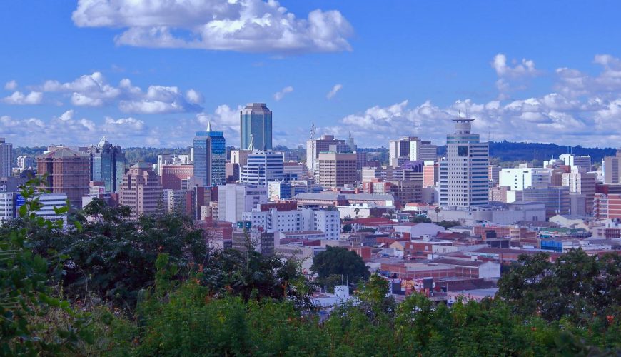
Harare is the capital of Zimbabwe. On the edge of landscaped Harare Gardens, the National Gallery of Zimbabwe has a large collection of African contemporary art and traditional pieces like baskets, textiles, jewelry and musical instruments. The unusual granite formation Epworth Balancing Rocks is southeast of the city. Wildlife such as zebras and giraffes roam Mukuvisi Woodlands, which has bike paths and a bird park
Hardap
-
- March 11, 2023 6:56 pm
- no comment
Hardap is one of the fourteen regions of Namibia, its capital is Mariental. Hardap contains the municipality of Mariental, the towns Rehoboth and Aranos, and the self-governed villages Gibeon, Gochas, Kalkrand, Stampriet and Maltahöhe. It is home to the Hardap Dam.
Hardap stretches the entire width of Namibia, from the Atlantic Ocean in the west to Namibia’s eastern national border. In the northeast, it borders the Kgalagadi District of Botswana, and in the southeast, it borders the Northern Cape Province of South Africa. Domestically, it borders the following regions:
Erongo
-
- March 11, 2023 6:54 pm
- no comment
Erongo is one of the 14 regions of Namibia. The capital is Swakopmund. It is named after Mount Erongo, a well-known landmark in Namibia and in this area. Erongo contains the municipalities of Walvis Bay, Swakopmund, Henties Bay and Omaruru, as well as the towns Arandis, Karibib and Usakos. All the main centres within this region are connected by paved roads.
The Erongo Region had a population of 150,809 in 2011.[3] As of 2020, it had 119,784 registered voters.[5]
In the west, Erongo has a shoreline on the Atlantic Ocean. On land, it borders the following regions:
Kunene – north
Otjozondjupa – northeast
Khomas – southeast
Hardap – south
Manicaland
-
- March 11, 2023 6:53 pm
- no comment
Manicaland is a province in eastern Zimbabwe. After Harare Province, it is the country’s second-most populous province, with a population of 2.037 million, as of the 2022 census. After Harare and Bulawayo provinces, it is Zimbabwe’s third-most densely populated province.